A mainly tech blog that sometimes touches politics and education. I use a Mac so you will hear about that and I live in Minneapolis, Minnesota USA so you will hear about our upcoming municipal Wi-Fi mesh network. I believe that open source is the only way to build big software so that may come up too. Est. 2004.
pfhyper[at]gmail.com
must remove NOSPAM before emailing!
PF Hyper Home
Bio & Resume
Profile
PF Hyper's Photos
Recent
Educated Guesswork: The Rapture Index
Public Access Surveillance
The del.icio.us Firefox Extension
Tiny Linux Browser
The Circus by Marcelo Montecino
How to Whistle Loudly
Microsoft + Yahoo?
Art Sales Today
Happy New Year
Wanted: Easy del.icio.us posting with a specified ...
Archives
02/01/2004 - 03/01/2004
05/01/2004 - 06/01/2004
09/01/2004 - 10/01/2004
10/01/2004 - 11/01/2004
11/01/2004 - 12/01/2004
12/01/2004 - 01/01/2005
01/01/2005 - 02/01/2005
02/01/2005 - 03/01/2005
03/01/2005 - 04/01/2005
04/01/2005 - 05/01/2005
05/01/2005 - 06/01/2005
06/01/2005 - 07/01/2005
07/01/2005 - 08/01/2005
08/01/2005 - 09/01/2005
09/01/2005 - 10/01/2005
10/01/2005 - 11/01/2005
11/01/2005 - 12/01/2005
12/01/2005 - 01/01/2006
01/01/2006 - 02/01/2006
02/01/2006 - 03/01/2006
03/01/2006 - 04/01/2006
04/01/2006 - 05/01/2006
05/01/2006 - 06/01/2006
06/01/2006 - 07/01/2006
07/01/2006 - 08/01/2006
08/01/2006 - 09/01/2006
09/01/2006 - 10/01/2006
10/01/2006 - 11/01/2006
11/01/2006 - 12/01/2006
12/01/2006 - 01/01/2007
01/01/2007 - 02/01/2007
02/01/2007 - 03/01/2007
03/01/2007 - 04/01/2007
04/01/2007 - 05/01/2007
05/01/2007 - 06/01/2007
06/01/2007 - 07/01/2007
07/01/2007 - 08/01/2007
08/01/2007 - 09/01/2007
09/01/2007 - 10/01/2007
10/01/2007 - 11/01/2007
11/01/2007 - 12/01/2007
12/01/2007 - 01/01/2008
01/01/2008 - 02/01/2008
02/01/2008 - 03/01/2008
03/01/2008 - 04/01/2008
05/01/2008 - 06/01/2008
06/01/2008 - 07/01/2008
07/01/2008 - 08/01/2008
08/01/2008 - 09/01/2008
10/01/2008 - 11/01/2008
11/01/2008 - 12/01/2008
12/01/2008 - 01/01/2009
01/01/2009 - 02/01/2009
02/01/2009 - 03/01/2009
03/01/2009 - 04/01/2009
05/01/2009 - 06/01/2009
07/01/2009 - 08/01/2009
08/01/2009 - 09/01/2009
09/01/2009 - 10/01/2009
10/01/2009 - 11/01/2009
11/01/2009 - 12/01/2009
12/01/2009 - 01/01/2010
01/01/2010 - 02/01/2010
02/01/2010 - 03/01/2010
03/01/2010 - 04/01/2010
04/01/2010 - 05/01/2010
Blogarama
Blog Directory

This work is licensed under a Creative Commons License.
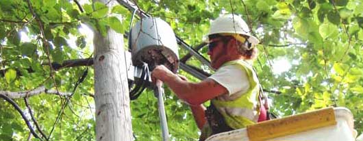
Worker adjusting the wireless access point outside my window.
Featured Tag: Wireless
Main Tags
art
blogging
learning
mac
movies
other
politics
science
tech
wireless
Wednesday, January 11, 2006
Google Earth Released for OS X Tiger
This is quite an amazing tool. I'm sure it's been blogged about ad nauseum in the Windows world where it appeared a while ago.
It's like the online maps.google.com except on steroids. As I move my pointer over my neighborhood, I get the elevation of the terrain and my 'eye altitude,' how high up I'm floating.
Zooming down results in a blurry image. There must be a way to find the optimum viewing altitude for a particular area. Well, it looks like certain areas have closer views available than others.
Clicking or searching for new locations results in a scan from where you are to where you want to go. There is a physical sensation of traveling which is nicely done.
Whoa. Clicking on the Google Earth Community layer over Richfield, MN resulted in a wifi placemark for Dunn Brothers appearing.
Thanks, Google.
Check The Savvy Technologist for some links to a podcast and some cool views of the Earth.
